 Kefalonia
-
classic Ionian island beauty
Kefalonia
-
classic Ionian island beauty 
Kefalonia Tour Trail Map
Kefalonia
-
classic Ionian island beauty
Water-proof, split-proof, tear-proof, adventure-proof. Kefalonia Tour & Trail Map is simply the toughest, most accurate, easy to read, easy to use map of the island you can buy at any price.
Kefalonia Tour & Trail
Map isbn 9781782750727 £10.99
published September 2020
Digital Editions
available from 
![]()
![]()
![]()
Your printed map includes details for you to download the Custom Map digital
edition free of charge. Your free download is a zip file which unzips into the
Custom Map files for Kefalonia NW, Kefalonia SE and Ithaca.
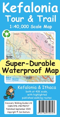
Kefalonia Tour & Trail Map is the most detailed, accurate, toughest,
large scale map of the island that you can buy. Super-Durable Maps now come with
a 2 year adventurous use 'Wear and Tear' guarantee, see Discovery Walking Guides
website for details.
Kefalonia was popularised and made famous by "Captain Corelli's Mandolin".
For your best adventures, use the best map.
Water-proof, split-proof, tear-proof, adventure-proof. Kefalonia & Ithaca Tour &
Trail Map is simply the toughest, most accurate, easy to read, easy to use map
of the island you can buy at any price.
A large 960mm by 690mm double sided map sheet has both Kefalonia and Ithaca at
1:40,000 scale.
The North-West of Kefalonia is on the cover side and the South-East of Kefalonia
with neighbouring island Ithaca on the reverse.
A generous common overlap of Kefalonia reduces the need to turn the map over
when navigating.
Our special concertina map fold makes your map easy to open and easy to refold
to its 230mm by 120mm pocket size.
Our legendary 'Tour & Trail' level of detail ranges from major roads to
secondary roads to minor roads to streets and narrow country roads, plus dirt
roads, tracks and walking trails.
Place names are in English and Greek to aid your navigation.
Altitude shading is designed to clearly show the altitude range when travelling
across the island by car or on foot.
20 metre and 100 metre contours combined with altitude shading bring this
beautiful landscape to life.
There are plenty of individual height points and all of the official 'Trig'
points are on the map.
Tour & Trail attention to detail includes our useful symbol range including
viewpoints, picnic areas, petrol stations, bar/restaurants and parking areas
where you can pull off the road safely.
You will easily identify springs, caves, sports grounds, cemeteries,
monasteries, churches, chapels, lighthouses, castles, camping areas, wind
turbines, hotels etc.
Published walking routes are clearly highlighted on the map.
It all adds up to the most detailed and most durable map of Kefalonia & Ithaca
that you can buy anywhere.
'Super-Durable' means a waterproof, tear-proof, map that can take the roughest
treatment and still folds up like new after your adventures.
Super-Durable Maps come with a 2 year adventurous use 'Wear and Tear' guarantee.
Super-Durable maps
are 100% recyclable.
Digital editions of Kefalonia Tour & Trail Map are
available for phone apps, Oziexplorer and Garmin users.
supported file formats:- Custom Map kmz, sqlite.db and Oziexplorer
Super-Durable maps
are 100% recyclable.
available from
![]()
![]()
![]()
Digital edition of Kefalonia Tour & Trail Map is available from
![]()
Click on one of the links below to change pages:
Home Page. Titles. Key Factors. Corfu Ibiza Mallorca. Menorca Tenerife. La Gomera. Walk! at Home-UK