 Corfu
-
classic beauty
Corfu
-
classic beauty 
Corfu Tour & Trail Map
Corfu
-
classic beauty
Water-proof, split-proof,
tear-proof, adventure-proof. Corfu Tour & Trail Super-Durable Map is simply
the toughest, most accurate, easy to read, easy to use map of the island you can
buy at any price. David & Ros Brawn surveyed this beautiful island in
2016 carrying out their ‘gps ground survey’ pinpointing all the details needed
to produce the definitive map of Corfu.
In 2019 we have updated/corrected our Corfu place names to correct some errors
in our 1st edition, along with a few minor updates. If you already own our Corfu
1st edition we suggest you continue to use it as these updates are a minor item.
Corfu Tour & Trail
Super-Durable Map isbn 9781782750628 £10.99
published 08 April 2019
Super-Durable Map - 2 Year Guarantee
available from
![]()
![]()
![]()

Digital editions of
Corfu Tour & Trail Map
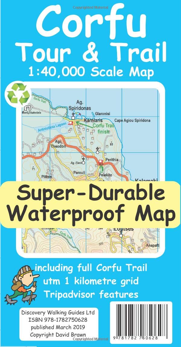
Corfu Tour & Trail Super-Durable Map is the most detailed, accurate, toughest,
large scale map of the island that you can buy. Super-Durable Maps now come with
a 2 year adventurous use wear and tear guarantee, see Discovery Walking Guides
website for details.
Our large 1:40,000 scale produces a double sided map sheet of 840mm by 680mm;
big enough to show masses of detail but compact enough to use in the car or on
the trail.
Corfu North is on the facing sheet of the map with Corfu South on the reverse
side, including a generous overlap between the two sides.
Our special concertina map fold means your map is easy to unfold, and more
importantly easy to refold back to its pocket size.
You get the most detailed map of Corfu that is produced including our 'Tour &
Trail' level of detail ranging from major roads to secondary roads to minor
roads to streets and narrow country roads, plus dirt roads and walking trails.
We have a new method of highlighting the full Corfu Trail, including its
options, with the trails, tracks, lanes and roads making up the Corfu Trail
being outlined in green. This makes it easier to identify the Corfu Trail on the
map and easier to find it on the ground.
Altitude background colouring is designed to clearly show the altitude range
when traveling across the island by car or on foot. 100 metre and 20 metre
contours are clearly shown on the map along with a large number of individual
height points.
Tour & Trail attention to detail is legendary as is our useful symbol range
including miradors, picnic areas, petrol stations, bar/restaurants and parking
areas where you can pull off the road safely.
New for our Corfu Tour & Trail Super-Durable Map we have introduced special
Place-Name Plaques for Tripadvisor's most popular destinations making them easy
to find.
For adventurers on foot Tour & Trail Maps are researched and designed by hikers
for use by hikers. Our comprehensive gps ground surveys produce the best road
mapping available but the value of this on the ground research becomes even more
important when you leave the tarmac.
Thinking of hiking the Corfu Trail? Download our DWG track file in gpx format -
corfu-trail.gpx
Super-Durable editions are printed with 100% oxygenation inks on Polyart by the
UK's leading map printer.This produces a Super-Durable Map that feels like silk
but will stand up to the roughest treatment of outdoor adventuring and yet fold
up like new at the end of your adventure.
Quite simply Corfu Tour & Trail Super-Durable Map is the most detailed,
accurate, toughest, large scale Corfu map that you can buy. Super-Durable maps
are 100% recyclable.
available from
![]()
![]()
![]() Digital editions of
Corfu Tour & Trail Map
Digital editions of
Corfu Tour & Trail Map
Click on one of the links below to change pages:
Home Page. Titles. Key Factors. Ibiza Mallorca. Menorca Tenerife. La Gomera. Walk! at Home-UK