 Rutland Water Challenge Map & Guide
OSlike Super-Durable Maps designed to help your successful challenge.
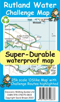
Rutland Water Challenge Map
Rutland Water Challenge Map & Guide
OSlike
Super-Durable Maps designed to help your successful challenge.
Rutland
Water Challenge Map at 25k scale with Challenge route highlighted. Isbn
9781782750833 £8.99
All hiking challenges are personal, yourself against the required completion
time. A successful Challenge is a personal triumph.
With its easy access, along with a wide, hard surfaced walkway the Rutland Water
Challenge is an ideal introduction to long distance walking.
Rutland Water is the UK's largest man-made lake set in 4,200 acres of parkland
including a wide, hard surfaced, walkway making the 'Water' an ideal
introduction to long distance walking.
There are four official, family friendly, recreation centres and nature reserves
including the Rutland Osprey Project.
Add in picturesque villages and the town of Oakham and you will soon understand
why Rutland Water has become one of England's favourite 'Daycation'
destinations.
Rutland Water Challenge Map and Guide is a 25k scale OSlike map with the
Challenge route specially highlighted.
We licence OS 50k scale mapping which is then doubled in size to produce an
OSlike 25k map but the features, text and logos are now doubled in size making
them much easier to read under Challenge conditions.
Rutland Water Challenge Route is added and specially highlighted so that our
route stands out against the OSlike 25k map.
Then we add the additional detail you might need including local hostelries
along with the three walking routes; Hambleton Peninsula 8.3kms, Circular
24.5kms and the full Challenge route at 36kms.
For each of the three routes we have gps track and waypoints as a gpx file; the
zip file of the gpx files is available as a free download.
These gps track and waypoints gpx files can be used on all gps phone apps and
gps units.
The 33 waypoints of the full Challenge route are highlighted on the map, and our
Rutland Water Challenge Map is available as a free digital Custom Map download
for Garmin gps users.
On the reverse of the map sheet is our Locator Map using OS Opendata showing the
location of, and access to, Rutland Water relative to a wide area of England.
The result is a double sided 600mm by 600mm
map design.
We then print the map design on a 100 micron plastic substrate using a special
UV curing inks process on the UK's only press capable of using this latest
technology.
The result is a lightweight map that is both waterproof and tearproof, and fully
recyclable, that will survive anything your Rutland Water Challenge can throw at
it and afterwards will fold up like new.

![]()
![]()
![]()
For buyers of Rutland Water Challenge Map we are pleased to offer you a free
Custom Map digital edition for use with Garmin software and gps units, plus use
in Google Earth.
Simply follow the 'Digital Custom Map Edition' information printed on the map
sheet.
National 3 Peaks Edale Skyline
Coast 2 Coast Isle of Wight
Yorkshire 3 Peaks
Surrey 3 Peaks
 Challenge Super-Durable Maps are printed on a special 100 micron plastic substrate
using UV cured inks which produces a lightweight map that feels like
silk while being both water-proof and incredibly tough so that after even the
toughest of adventures your Challenge Super-Durable Map will fold up like
new. All materials used in producing Challenge Super-Durable Maps are 100% recyclable in category 2 HDPE.
Challenge Super-Durable Maps are printed on a special 100 micron plastic substrate
using UV cured inks which produces a lightweight map that feels like
silk while being both water-proof and incredibly tough so that after even the
toughest of adventures your Challenge Super-Durable Map will fold up like
new. All materials used in producing Challenge Super-Durable Maps are 100% recyclable in category 2 HDPE.
Click
on the links below to move to another page:
Home Page. Madeira
Mallorca Menorca
Alpujarras Axarquia
Costa Blanca Mountains
Sierra de Aracena
Lanzarote Tenerife
Gran Canaria La Palma
La Gomera Fuerteventura DWG sitemap
Unsure about DWG books and maps? Email us with
your thoughts and ideas.