Rhodes Tour and Trail Map Compendium edition
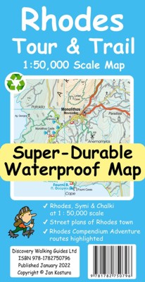 Rhodes Tour & Trail Map - Compendium edition
Upgraded digital editions for Compendium users available as in-app purchase for Outdooractive and Locus Map app users
DWG offer digital editions in kmz (Garmin), sqlite.db (app users), Oziexplorer choice of formats for
digital users
isbn
978-1782750-796 £10.99


2022 sees the launch of our Compendium
editions of Tour and Trail Maps
For your best adventures, use the
best map. Water-proof, split-proof, tear-proof. Rhodes Tour & Trail
Super-Durable Map is simply the toughest, most accurate, easy to read, easy to
use map that you can buy at any price.
A large 960mm by 700mm double sided map sheet covers Rhodes at 1:50,000 scale
and includes Chalki and Symi islets.
On the cover side is Rhodes South with Chalki and Symi, with Rhodes North and
street plans of Rhodes Town on the reverse.
We have two street plans of the capital town. Rhodes Town greater area is at 12k
scale, including Acropolis in the west and spanning beyond Rodini park in the
south. The other street plan shows the fortified Old Town in great detail at 5k
scale.
DWG's special concertina map
fold makes our map easy to open and easy to refold to its 233mm by 120mm pocket
size.
Our legendary 'Tour & Trail' level of detail ranges from major roads to
secondary roads to minor roads to streets and narrow country roads, plus dirt
roads, tracks and walking trails. Place names are in English and Greek to aid
your navigation.
Altitude shading is designed to clearly show the altitude range when travelling
across the island by car or on foot. 20 metre and 100 metre contours combined
with altitude shading bring this beautiful landscape to life. There are plenty
of individual height points and all of the official 'Trig' points are on the
map.
Tour & Trail attention to detail includes our useful symbol range including
viewpoints, picnic areas, petrol stations, bar/restaurants and parking areas
where you can pull off the road safely. You will easily identify springs, caves,
sports grounds, cemeteries, monasteries, churches, chapels, lighthouses,
castles, camping areas, wind turbines, windmills, hotels etc.
Rhodes Compendium of Walking
Adventures walking routes (all 98 walking routes) are specially highlighted on
the map.
It all adds up to the most
detailed, most durable map of Rhodes, Chalki and Symi that you can buy anywhere.
'Super-Durable' means a waterproof, tear-proof, map that can take the roughest
treatment and still folds up like new after your adventures. Super-Durable Maps
come with a 2 year adventurous use 'Wear and Tear' guarantee.
isbn
978-1782750-796 £10.99
Rhodes Tour & Trail Map -
Compendium edition £5.99 from DWG
If you are a Garmin user then our kmz Garmin Custom Map file format is your
choice for use in Garmin Basecamp, in your gps and in Google Earth. Check that
your Garmin will accept Custom Maps before purchasing.
Quite a few gps apps use the sqlite.db digital map format. If your app uses the
sqlite.db format and allows you to import maps then choose the sqlite.db option.
If you use Oziexplorer software we produce a map image as an 8bit colour png image and
map calibration files that you can use directly with Oziexplorer including
conversion for the Oziexplorer Android app.
Rhodes is a large island so our digital maps use the same layout as our printed
Tour & Trail Map with seperate North and South map sheets; unzip your map
purchase before trying to use the maps.
Check our email Digital
Purchase system before ordering
DWG delivers all of our digital products as an email containing an encrypted
hyperlink from dwgwalking.co.uk
As many isp email services have high security measures these hyperlink emails
are often rejected or placed in your Spam folder.
Our email is sent to the email address linked to your PayPal account; the email
cannot be sent to any other address.
Before ordering check that your email (linked to your PayPal account) will
accept our emails by emailing to:-
testpurchase@dwgwalking.co.uk
If you receive our email with a hyperlink to this website you are clear to order
If you do not receive the email within 5 minutes you need to reset your email
account to accept emails from dwgwalking.co.uk
Repeat until you are 'clear to order'
Please action your map purchase and emails on your computer, not your phone
Buy your Rhodes
Tour & Trail Map - Compendium edition
Choose which version of the map is
suitable for your app -
Garmin Custom Map

sqlite.db format digital
map
Oziexplorer png image +
click 2022 Rhodes Calibration
Files.zip for your calibration files
see Amelia Bolger's 3 Stunning Walks in Fuerteventura on Youtube
Click
on the links below to move to another page:
Home Page. Madeira
Mallorca Menorca
Alpujarras Axarquia
Costa Blanca Mountains
Sierra de Aracena
Lanzarote Tenerife
Gran Canaria La Palma
La Gomera Fuerteventura