.
![]() Trail
Report - Mount Teide (Tenerife) by Mike Reid (March 2000 and still as relevant in 2010)
Trail
Report - Mount Teide (Tenerife) by Mike Reid (March 2000 and still as relevant in 2010)
 At 3717.91 metres (12198 ft) the volcano
Teide (Tay-dee) on the island of Tenerife (Tenner-reef-ay) forms
the highest peak on Spanish territory. It and the much older
extinct crater it stands in are designated as a national park and
access to the summit cone is strictly controlled. Without a
summit permit (free) walkers are only allowed as far as the two
miradors (viewpoints) and their connecting path which contour the
base of the final summit cone at the top of the teleferico (cable
car). This restriction is essential because of the potential
erosion and disturbance that would be caused by cablecar tourists
going to the summit (2.5m visitors a year). The National Park are
taking all precautions to protect the natural environment of the
park, for example all the 4x4 tracks in the park are now closed
to non official traffic. There are also rumours that the
teleferico will be closed when its operating license expires.
Large numbers of coach bourne tourists enter the park each day
but concentrate at the teleferico, Los Roques and a patch of
pleasant pumice convenient for coach parking. Once 50 metres from
these three sites you will enjoy reasonable solitude. If staying
at the Parador I suggest starting the Los Roques walk at dawn for
dramatic lighting and solitude (walk in an anticlockwise
direction, you may see Barbary Partridges here), returning for a
late breakfast (until 11.a.m). Guajara (gwar-har-ah) and the
other summits of the old crater rim may also be climbed from the
Parador. Another highlight of a stay at the Parador is the night
sky, unsullied by light pollution, groups regularly visit for
dinner, an astronomical talk and night stroll. For the ultimate
night sky/sunrise experience arrange to stay a night in the ICONA
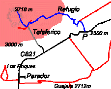
refugio Altavista near the summit. The Teide path is shown in
blue, other paths in red, roads in black and the teleferico in
grey. (Not to scale). About ten cars can be parked at 'P' and
overflow parking is possible, if needed, a little to the west at
a mirador. The only accomodation and meals are available at the
Parador (4 star mountain lodge style hotel with seperate
cafeteria, alt. 2200 metres) and accomodation only at the Refugio
de Altavista (alt. 3250 metres). Light refreshments are available
at both top and bottom stations of the teleferico. There are no
shops or petrol available in the national park so any supplies
should be purchased at the coast or Vilaflor before tackling the
unremitting climb of one of the roads into the crater (2 hours
drive from airport to Parador - buses also run to the park). The
nearest town to the Park is Vilaflor to the south (1466m) with
shops, bars and accommodation. The Las Lajas zona recreational at
the south edge of the park has camping and a restaurante but is
packed with barbecuing locals and coach parties at the weekend.
(This is incidentally a good place to see the Tenerife Blue
Chaffinch)
At 3717.91 metres (12198 ft) the volcano
Teide (Tay-dee) on the island of Tenerife (Tenner-reef-ay) forms
the highest peak on Spanish territory. It and the much older
extinct crater it stands in are designated as a national park and
access to the summit cone is strictly controlled. Without a
summit permit (free) walkers are only allowed as far as the two
miradors (viewpoints) and their connecting path which contour the
base of the final summit cone at the top of the teleferico (cable
car). This restriction is essential because of the potential
erosion and disturbance that would be caused by cablecar tourists
going to the summit (2.5m visitors a year). The National Park are
taking all precautions to protect the natural environment of the
park, for example all the 4x4 tracks in the park are now closed
to non official traffic. There are also rumours that the
teleferico will be closed when its operating license expires.
Large numbers of coach bourne tourists enter the park each day
but concentrate at the teleferico, Los Roques and a patch of
pleasant pumice convenient for coach parking. Once 50 metres from
these three sites you will enjoy reasonable solitude. If staying
at the Parador I suggest starting the Los Roques walk at dawn for
dramatic lighting and solitude (walk in an anticlockwise
direction, you may see Barbary Partridges here), returning for a
late breakfast (until 11.a.m). Guajara (gwar-har-ah) and the
other summits of the old crater rim may also be climbed from the
Parador. Another highlight of a stay at the Parador is the night
sky, unsullied by light pollution, groups regularly visit for
dinner, an astronomical talk and night stroll. For the ultimate
night sky/sunrise experience arrange to stay a night in the ICONA
refugio Altavista near the summit. The Teide path is shown in
blue, other paths in red, roads in black and the teleferico in
grey. (Not to scale). About ten cars can be parked at 'P' and
overflow parking is possible, if needed, a little to the west at
a mirador. The only accomodation and meals are available at the
Parador (4 star mountain lodge style hotel with seperate
cafeteria, alt. 2200 metres) and accomodation only at the Refugio
de Altavista (alt. 3250 metres). Light refreshments are available
at both top and bottom stations of the teleferico. There are no
shops or petrol available in the national park so any supplies
should be purchased at the coast or Vilaflor before tackling the
unremitting climb of one of the roads into the crater (2 hours
drive from airport to Parador - buses also run to the park). The
nearest town to the Park is Vilaflor to the south (1466m) with
shops, bars and accommodation. The Las Lajas zona recreational at
the south edge of the park has camping and a restaurante but is
packed with barbecuing locals and coach parties at the weekend.
(This is incidentally a good place to see the Tenerife Blue
Chaffinch)
![]() Climbing Teide 'Grade'. The path is well
within the capacity of any British hillwalker without any
scrambling being involved. It will be of interest to any walker
who does not normally go this high, enjoys excellent views, or is
interested in the novel experience, for the British walker, of
climbing on a volcano. The only difficulties are lack of oxygen (
50% of sea level value at summit) and summer heat. Persons with a
heart condition or who are pregnant should not attempt the climb.
Long trousers, water, a fleece and lightweight waterproof jacket
should be carried. In winter the usual additional equipment is
required including glacier glasses to avoid snow blindness. (The
angle of ascent is on average 7 and at maximum 12%). Timing. If
climbing Teide in hot weather I recommend being on the hill
before dawn, to avoid being caught by the sun low down on the
mountain. This approach gives the bonus of watching the sun rise
over the national park. (The start of the track is easy to follow
by head torch.) Allow 5 hours (one way). Total ascent by this
route is 1418 metres (4652 ft), not much more than Ben Nevis!
Climbing Teide 'Grade'. The path is well
within the capacity of any British hillwalker without any
scrambling being involved. It will be of interest to any walker
who does not normally go this high, enjoys excellent views, or is
interested in the novel experience, for the British walker, of
climbing on a volcano. The only difficulties are lack of oxygen (
50% of sea level value at summit) and summer heat. Persons with a
heart condition or who are pregnant should not attempt the climb.
Long trousers, water, a fleece and lightweight waterproof jacket
should be carried. In winter the usual additional equipment is
required including glacier glasses to avoid snow blindness. (The
angle of ascent is on average 7 and at maximum 12%). Timing. If
climbing Teide in hot weather I recommend being on the hill
before dawn, to avoid being caught by the sun low down on the
mountain. This approach gives the bonus of watching the sun rise
over the national park. (The start of the track is easy to follow
by head torch.) Allow 5 hours (one way). Total ascent by this
route is 1418 metres (4652 ft), not much more than Ben Nevis!
Route. The path starts as a jeep track (closed to public) to the east of a prominent mirador. Signs and a large map mark the start. Keep to the track on an easy gradient, zig-zagging up past the "eggs of Teide" (large black rocks hurled from the volcano mouth) until signs indicate the start of the footpath which now leaves the pumice slopes and ascends the edge of a lava flow until being eventually forced onto the lava itself. Once on the lava you will be glad of the well engineered path across the uneven surface. Keep climbing up past the refuge on its left (west) side until you meet the mirador path just below the summit. Between the refugio and the mirador you can take a detour to an old commercial ice cave in use until 1900. Turn left onto that path. Now may be the time to put your head down and get through the tourists getting in the way. I found chanting a little mantra in my head helped here ("I've got a summit permit, you havn't"). When you reach the teleferico top station in a few minutes you will see the summit path on your right just before the building, the start guarded by a rope and a large, stern ranger. Once your permit and passport have been inspected you will be allowed onto the 'Telesforo Bravo' path to the summit. The path climbs steeply up the summit cone of yellow rocks ending on the lip of the crater. You may continue on from here anti-clockwise round the crater, stepping over small fumeroles venting scalding sulphourous vapours, to about half way where a length of rope indicates the section of the summit being preserved from all erosion. The views in all directions are spectacular, Tenerife's famous cloud seas (a near permenent inversion aloft caused by the NE Trade winds " Los Vientos Alisios") are now as much as 2000 metres below you and the Parador and El Roques look insignificant in the outer crater. If haze is low you will be able to see the other Canary islands rising up out of the clouds. When you have had enough of the views and retrace your steps to the teleferico, the guard will return your permit as a souvenier and you have the choice of walking back down or taking the cablecar (8 minutes - 20 Euros). The cablecar is a good option if the day is becoming hot but bear in mind you must take care in returning to your car along the road. Do not become trapped between the retaining wall and passing vehicles. On your return the Parador cafeteria has draught Dorada and a telescope on the terrace to admire your climb.
Obtaining your summit permit. Summit permits (free) are obtainable only in person from :-ICONA Office P. N. de Teide, Calle Emillio Calzadilla 5. 38002 Santa Cruz de Tenerife Phone 922 29 01 29 or 922 29 01 83 Opening hours (Monday to Friday except public holidays) 9 am to 2 pm. Park in the underground carpark by the Plaza España (an impressive pedestrianised square with the town hall on one side) on the seafront. Calle Emillio Calzadilla runs at right angles to the coast road to the east of the Plaza España.The office is on the forth floor of number 5 (press entryphone and enter). English usually spoken. If office has moved enquire at the town hall nearby. You must present your passports here AND on the mountain. You will be allocated two days on which to make an ascent (in August the following two days were available) and must specify a summit slot of two hours (allow 5 hours for climb). Only one ascent on one of the two days may be made, but you may of course abort an ascent at any time before the summit checkpoint. Late/early arrivals at the summit checkpoint will be treated sympathetically at the discretion of the ranger. Maximum party size 10.
FACT FILE Mike Reid is a keen UK and Spain walker.