 La Palma
Tour & Trail Map
La Palma
Tour & Trail Map
Super-Durable 6th Edition isbn 9781782750444 £10.99 Digital editions including 2021 eruption lava fields
La Palma Tour Trail Map Spain
La Palma
Tour & Trail Map
Super-Durable 6th Edition isbn 9781782750444 £10.99
Digital editions including 2021 eruption lava fields
Water-proof, split-proof, tear-proof, adventure-proof.
La Palma Tour & Trail Super-Durable Map is simply the toughest, most accurate,
easy to read, easy to use map of the island you can buy at any price.
Super-Durable Maps now come with a 2 year adventurous use wear and tear
guarantee, see Discovery Walking Guides website for details.
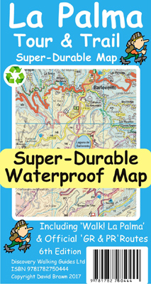
6th Edition of our La Palma Tour & Trail Super-Durable Map is a large 1:40,000
scale map, splitting the island into a North (Landscape view) and South
(Portrait view) with a generous overlap, produces double sided map of 840mm by
600mm and folds to 235mm by 120mm. Our legendary 'Tour & Trail' level of detail
ranges from major roads to secondary roads to minor roads to streets and camino
rural narrow country roads, plus dirt roads and walking trails.
Altitude background colouring is designed to clearly show the altitude range
when travelling across the island by car or on foot. 100 metre and 50 metre
contours are clearly shown on the map along with a large number of individual
height points and all of the official 'Trig' points.
Tour & Trail attention to detail includes our useful symbol range including
miradors, picnic areas, petrol stations, bar/restaurants and parking areas where
you can pull off the road safely. You will easily identify springs, caves,
sports grounds, cemeterys, churchs, chapels, lighthouses, towers and forts,
camping areas, wind turbines, hotels etc.
For adventurers on foot Tour & Trail Maps are researched and designed by hikers
for use by hikers.
Our comprehensive gps ground surveys produce the best road mapping available but
the value of this on the ground research becomes even more important when you
leave the tarmac. All of our DWG walking routes are accurately gps surveyed
giving you confidence in the accuracy of our Tour & Trail Maps. La Palma Tour &
Trail Super-Durable Map includes all the walking routes from Walk! La Palma
(highlighted in red) along with the GR130 (in eight one day sections) and GR131
(in three one day sections) long distance hiking routes (highlighted in green),
plus details of the PR walking routes (Pequeno Recoridos, highlighted in
purple), plus details of the SL walking routes (Senderos Locales).
It all adds up to the most detailed, most durable, most useful map of La Palma
that you can buy anywhere. 'Super-Durable' means a waterproof, tear-proof, map
that can take the roughest treatment and still folds up like new after your
adventures.
Printed on Polyart using specialist 100% oxygenation inks produces a lightweight
map that feels like silk but is a tough as old boots as it shrugs off water,
resists tearing and damage better than any other map.
'Super-Durable' combined with our special concertina map fold means this 'near
indestructible' Tour & Trail Map unfolds easily for use, and more importantly
folds back up easily to its compact pocket size even after the toughest use.
 Tour & Trail Super-Durable Maps are printed on Polyart using 100% oxygenation
inks which produces a lightweight map that feels like silk while being both
water-proof and incredibly tough so that after even the toughest of adventures
your Tour & Trail Super-Durable Map will fold up like new. Polyart is made of
high-density polyethylene (HDPE) and is therefore 100% recyclable in category 2
HDPE.
Tour & Trail Super-Durable Maps are printed on Polyart using 100% oxygenation
inks which produces a lightweight map that feels like silk while being both
water-proof and incredibly tough so that after even the toughest of adventures
your Tour & Trail Super-Durable Map will fold up like new. Polyart is made of
high-density polyethylene (HDPE) and is therefore 100% recyclable in category 2
HDPE.
For more information see the Polyart website at http://www.polyart.com/en
La Palma Tour & Trail
Super-Durable Map (2017 - 6th edition)
isbn 9781782750444 £10.99.

![]()
![]()
![]()
. . .
Digital editions of La Palma Tour & Trail Map
including 2021 volcanic eruption lava fields are available for phone apps, Oziexplorer and Garmin users.
supported file formats:- Custom Map kmz, sqlite.db and Oziexplorer
Digital
edition is available ![]()
La Palma main page Gran Canaria Alpujarras Menorca, Mallorca, Madeira, La Gomera, Titles