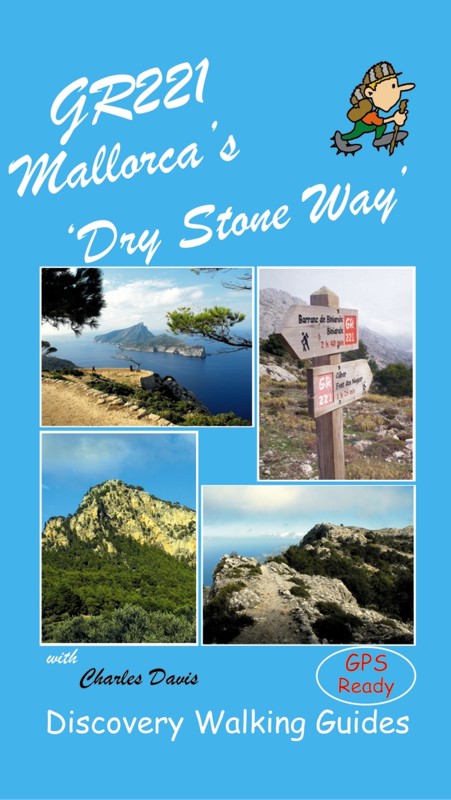
 GR221
Mallorca's 'Dry Stone Way'
£12.99 isbn 9781904946489
GR221
Mallorca's 'Dry Stone Way'
£12.99 isbn 9781904946489 
See Chris and Carol Sealy's Trail Report GPS navigation files available - see GPX Downloads
Walk Mallorca Guide Book Specification Contents
GR221
Mallorca's 'Dry Stone Way'
£12.99 isbn 9781904946489
![]()
![]()
![]()
See Chris and
Carol Sealy's Trail Report
GPS navigation files available - see GPX Downloads
 Specification: 160 page full colour paperback
guidebook. Page size 210mm by 120mm. Weight 250 grams. Map
sections adapted from Mallorca North & Mountains Tour &
Trail Map at 1:40,000 scale. Dedicated map sections for each walking stage
only showing the waypoints for that stage to avoid confusion. Altitude
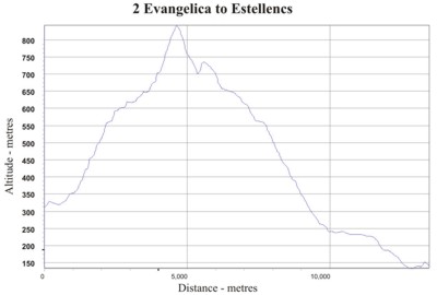
Profiles for each walking stage. Colour
photographs. Stitched and perfect bound binding.
Specification: 160 page full colour paperback
guidebook. Page size 210mm by 120mm. Weight 250 grams. Map
sections adapted from Mallorca North & Mountains Tour &
Trail Map at 1:40,000 scale. Dedicated map sections for each walking stage
only showing the waypoints for that stage to avoid confusion. Altitude
Profiles for each walking stage. Colour
photographs. Stitched and perfect bound binding.
CONTENTS
The Author
Introduction
One of Europe's great walking experiences
GR221 - The Dry Stone Way
The Route, State of the route & options, Refuges / Accommodation
Structure of the book
Where to start
What to think about and what to take
When to go
On arrival
Symbols Rating Guide & Walking Equipment
Tour & Trail Map Sections & Altitude Profiles
Town Sketch - Andratx
Stage One - Port d'Andratx to La Trapa & S'Arraco
1A Port d’Andratx to Sant Elm 2 hrs, 7 kms, Ascents & Descents
300m
1B Sant Elm to La Trapa plus extension to S’Arraco
3½ hrs, 11¼ kms, Ascents 500m, Descents 420m
Alternative Stage 1A - Es Capdella to Estellencs
2½ hrs, 8.8 kms, Ascents 480m, Descents 450m
Alternative Stage 1B - Puigpunyent to Estellencs
2¼ hrs, 8 kms, Ascents 400m, Descents 500m
Gobbet: The Colours They Make - Mallorcan Flora
Stage Two - Ses Basses / Pla de s'Evangèlica to Estellencs
Ses Basses to Pla de s’Evangelica link
1 hr, 4¾ kms, Ascents 90m, Descents 120m
Evangelica to Estellencs
3½ hrs, 12 kms, Ascents 550m, Descents 700m
Gobbet: The Perils of Science
Town Sketch - Estellencs and Banyalbufar
Stage Three - Estellencs to Esporles
3A Estellencs to Banyulbufar
¾ hr, 3 km (+ 3km road) Ascents 120m, Descents
165m
3B Banyalbufar to Esporles
2 hrs, 6.9 km, Ascents 330m, Descents 260m
Town Sketch - Esporles and Valldemossa
Stage Four - Esporles to Deià
4A Esporles to Valledemossa
2¾ hrs, 8.2 km, Ascents 570m, Descents 360m
4B Valledemossa to Deia
3 hrs, 7.9 km, Ascents 520m, Descents 800m
Gobbet: Sitjes, Hornos de Calc & Casas de Nieve
Gobbet: Mallorca's First Ecologist
Gobbet: Mallorca's First Celebrities
Town Sketch - Deià
Gobbet: Literary Mallorca
Stage Five - Deià to Sóller
3¼ hrs, 12.5 km, Ascents 280m, Descents 415m
Town Sketch - Sóller
Stage Six - Sóller to Tossals Verds
6A Soller to Cuber
3¼ hrs, 10.5 km, Ascents 880m, Descents 140m
6B Cuber to Tossals Verds official route
2 hrs, 5.3 km, Ascents 80m, Descents 230m
6B Alt Cuber to Tossals Verds via Pas Llis
2 hrs, 4.8 km, Ascents 150m, Descents 410m
Gobbet: El Fumat & Canaleta de Massanella
Stage Seven - Tossals Verds to Lluc
7A Tossals Verds to Font des Prat turn-off
1 hr, 3km, Ascents 200m, Descents neg
7B Font des Prat turn-off to Lluc
3 hrs, 11 km, Ascents 500m, Descents 800m
Gobbet: Food & Wine
Town Sketch - Escorca
Gobbet: Twitchers' - Mallorca Birdlife
Stage Eight - Lluc to Pollença
3¾ hrs, 14.5 km, Ascents 160m, Descents 635m
Town Sketch - Pollença
Glossary
Appendices
A. Distance & services summary
B. Accommodation Guide
C. Transport
D. Links to other walks
E. Additional information
Using GPS on Mallorca’s GR221
Waypoint Lists
GPS navigation files available - see GPX Downloads
![]()
![]()
Back to Walk!
Mallorca North & Mountains main web page